Hampta Pass Trek
6D – 5N | Manali to Manali
Enquire for Group Booking
↬ Description
- Altitude : 14000 ft.
- Duration: 6 Days
- Trek Length: 26 kms
- Base Camp: Manali
The entrancing Hampta Pass may be found hidden away in the mystical highlands of Kullu, which are found in Himachal Pradesh. The Kullu valley, which is located on one side of the journey, has a diverse environment that includes flowers, waterfalls, streams, and woods, while the Lahaul valley, which is located on the other side, features a large stretch of arid and lonely mountains. The trip lasts for five days and covers a total distance of 22 km. There are few steep ascents or descents, and the landscape changes in unexpected ways throughout. The enchanting Rani nallah is our travelling companion for the first two days of the trip. After a few spectacular river crossings on the third day, we start rising towards the pass, which is perched at a height of 4,200 metres. The walk comes to a finish at the picturesque Chandra Tal lake, which is located at a high altitude and is known for its beauty. This beautiful, emerald-green lake can be found at an elevation of 4,250 metres, and it is renowned for both its tranquilly and its splendour. The months of June through October are great for completing this walk since that is when the enchantment of monsoon showers brings a diverse range of flowers and hues to life. Because of the soft, white clouds that often cover the landscape, the area is well-known for its regular whiteouts. The highlights of Hampta Pass include moving through cotton clouds, camping next to the mellow flow of rivers, having lunch on meadows filled with vibrant flowers, strolling on quaint bridges, traversing the snow-covered pass, resting near small waterfalls, and experiencing soothing showers. Other highlights include moving through the snow-covered pass, passing through the snow-covered pass, walking on snow-covered bridges, and walking on snow-covered bridges. Check read this article to learn more about the trip’s highlights: Highlights of the Hampta Pass Trek.
↬ Itinerary
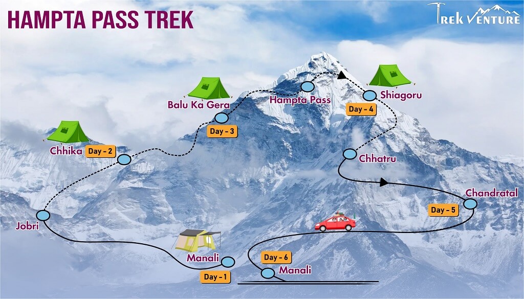
Day 1: Manali arrival
After departing from Delhi, you would get to Manali about noon on the next day. Our guest house is situated in Vashisht, which is 2050 metres or 6725 feet away from the centre of Manali and can be reached by auto rickshaw for Rs 150 or Rs 200. The temple in Vashisht is famous for the natural hot spring that can be found inside it. Spend the day on a walk to Jogini Falls, which is just a couple of hours away. Guests may choose to stay in either a lodge or a guest house during their visit.
Day 2: From Manali to Jobri drive and Chhika trek
Today we will begin our journey by travelling around 30 kilometres from the hamlet of Preni to the Jobri roadhead, which is located at an elevation of approximately 2850 metres (9350 feet). The path is quite difficult to navigate due to the many sharp turns and steep inclines it has. Jobri is not a village, although it does have a few temporary buildings for the local employees that are employed at the hydro power plant. The journey will start from this location. After passing over a concrete bridge, we make a turn to the left. On our left, we are able to keep access to the Aleo Nallah. After passing across the Aleo Nallah, the trail emerges from the confer woods onto an open meadow after taking a winding path through the forest. After a very simple hike of 5 km, which will take between 2 and 3 hours to complete, we will set up camp in Chhika, which is at an elevation of 3020 metres or 9905 feet. Along the stream’s left bank is where you’ll find the designated camping area. A beautiful waterfall may be observed from the campsite’s elevated vantage point.
Read MoreDay 3: Trek from Chhika to Balu Ka Gera
Following breakfast, we make our way to Bhalu-Ka-Gera, also known as “Bear’s Circle,” which is a mountain pass at 3,600 metres and 11,800 feet in elevation. It is here that brown bears are said to spend the winter months hibernating. Shortly after departing from the campground, we make our way over a small brook through a wooden bridge that spans it. We keep to the left side of the valley as we gradually make our way up the slopes of Aleo Nallah. The valley is covered in a profusion of wildflowers, making today’s walk an especially lovely one. The next obstacle is a raging side stream that feeds into the main Aleo Nallah and has to be across. Because the water level will continue to rise throughout the day, it is best to make this crossing as early in the morning as possible. After we have crossed the river, we keep going on the left side of the trail and gradually climb higher until we reach the campsite. The journey is around 8 km long, and it might take anywhere from four to five hours to finish.
Day 4: Trek from Balu Ka Gera to Shiagoru via Hampta pass
We get an early start and stay on the left top of the valley as we go forward. Depending on the time of year, the river may include many snow bridges, one of which we happened to come upon. Keep going left to reach the Lahaul side and go across Hampta Pass, which is at 4270 metres or 14005 feet in elevation. The ice field that lies below the pass maintains practically all of its original integrity throughout the whole year. The climb up to the pass is very easy, but the last crest is a little steeper than the rest. After climbing to the top of the pass, we make a precipitous descent to a flat region that is littered with stones. Now we will continue to keep to our left and follow another stream that is flowing down from the higher reaches of the mountains. After a very level journey, we reach Shiagoru, which is located 3,800 metres / 12,470 feet below our starting point at the river. The journey is about 9 km long, and it may take anything from 8 to 10 hours to finish.
Day 5: Trek from Shiagoru to Chhatru and drive to chandratal
The first thing we do in the morning is go over the river while keeping to the left side of it. During the first part of the hike, we have no trouble following our descent as we walk alongside the river. However, once we reach the boulder and rock zone, things get more difficult. After a descent, we emerge into a large valley formed by the Chandra River and are able to make out the automobile path that connects Spiti and Kaza. We continue our walk by going over the log bridge that spans the side stream and staying to the right of the Chandra River the whole time. On the left bank of the Chandra, at an elevation of 3350 metres (11000 feet), we set up camp. The dismal brown and white beauty of the Trans Himalaya is on full display at this location, which is on the route from Kaza to Manali. A few seasonal Dhabas are located on the other bank of the river, and one may get there by crossing the steel bridge that is located on the Kaza road. It is possible that it will take between three and four hours to finish the journey, which is around seven km in distance. This is where we set up our tents for the night. The path to Chandra Tal is often passable by the end of June, and it remains so until around the middle of October. In the event that the road leading to Chandra Tal is impassable, our next destination will be Kunzum La, a high pass that divides Lahaul and Spiti. We get in the vehicle and go to Batal by way of Chhota Dhara and the road that goes via Kaza. From Batal, we have the option of continuing on to either Chandra Tal (4300 m/14100 ft) or Kunzum La (4300 m/14100 ft), both of which are almost exactly at the same height. Moon-shaped and very transparent, Chandra Tal is surrounded by some of the most magnificent mountains in the world. From Kunzum, one may get a good look of the mountains that make up the Chandra Bhaga (CB) range. This location is home to a monastic community as well as a Chorten that is adorned with vibrant prayer flags.
Day 6: Drive back to Manali
After we eat breakfast this morning, we are going to begin our journey to Manali via the Rohtang Pass. We landed at Manali at about 2:00 in the afternoon. Our adventure comes to an end right here, at this very spot. You may either remain the night in Delhi or take a bus to Delhi in the afternoon or evening.
↬ Map of Hampta Pass Trek

↬ Inclusion
- From Day 1 through Day 6 of your walk, you will be sleeping in various hotels and tents.
- All meals are provided, beginning with the first night’s dinner and ending with breakfast on day sixth. On all days of the walk, we provide simple, healthy vegetarian meals.
- We will provide for round-trip transportation from Manali to Manali
- Trekking permits and camping expenses in the woods are all accounted for.
- Tents and sleeping bags of the highest quality will be provided at each camp. Fortunately, we have high-altitude sleeping bags that are good down to ten degrees Celsius.
- Gaiters, microspikes, and ropes are available.
↬ Exclusion
- Costs associated with carrying personal items, such as luggage, on the hike.
- The term “emergency costs” refers to any and all costs that crop up as a direct consequence of a crisis.
- There will be no access to bottled water at any point throughout the walk.


