Brahmatal Trek
6D – 5N | Rishikesh to Rishikesh
Enquire for Group Booking
↬ Description
- Altitude : 13100 ft.
- Duration: 6 Days
- Trek Length: 31kms
- Base Camp: Lohajung
Brahmatal journey (pronounce “Brahma Tal”) is one of the most beautiful treks in the world, and there are comparable paths in the Himalayas, but at a much greater altitude. The Brahma Tal trip is a simple winter hike that has about everything you might want from a winter hiking location. The Brahmatal walk is quickly gaining popularity because to its breathtaking scenery. This walk has a lot going for it, including seemingly endless ridge lines, expansive and pleasant alpine meadows/Bugyal, high altitude lakes, and vistas of beautiful peaks. You’ll want to put the Brahmatal winter trek on your itinerary for more than just the stunning landscapes you’ll see. Brahmatal is a medium-sized lake hidden behind the ridge (coordinates: 30.176878°E, 79.589449°N), and it can be found only by descending from the peak. Lord Brahma, according to myth, did some soul-searching here beside the lake. Bekhal Tal, the second lake on the route, is similarly concealed by the surrounding woodland. Many of you may easily miss it, therefore your guide will likely point it out to you. Both lakes are about the size of a standard one, given that they are so far up. From the route’s highest points, you have a breathtaking view of the High Himalayan ranges stretching from east to west. The peaks of Mrigthuni, Devtoli, and Maikoti in Kumaon may be seen on the right as you go north-east. The Trisul mountain and the enormous Nanda Ghunti to the north are spectacular. Nandaghunti and the Bethartoli Himal. The towering peaks of Chaukhamba, Neelkanth, Mana, Kamet, Hathi, and Ghoda may be seen to the west and left. Views of Ali Bugyal, Bedni Bugyal, Roopkund, Junargali, and the distant Ronty saddle, among others, can be seen from this ridge, which is directly opposite the more well-known Roopkund trek.
↬ Itinerary
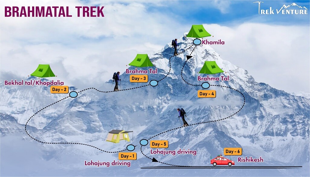
Day 1- From Rishikesh to Lohajung driving
Pickup will take place at Rishikesh in the morning, and the journey to Lohajung ( 2320 m/7600 ft) is around 220 km long. It’s possible that the trip will take roughly 10 hours, including breaks. The route travels through the Kumaon area and, for the most part, follows the vast valleys that are found in the Shivalik Himalaya. Along the way, we pass through Almora and Kausani. The route progressively winds its way through the conifer forest and reaches the Garhwal administrative area after passing through Gwaldam. The road is named after the Garhwal administrative region. A significant amount of elevation is gained over the last leg of the trek from Deval to Lohajung. In addition to a handful of private hotels, Lohajung is home to a GMVN tourist lodge and a Tourist Rest House. Connectivity is available from all of the main mobile networks here. The view of the sunset from Lohajung absolutely warrants a separate remark. The Nandaghunti massif’s warm hues may likely leave you unable to find words to describe them. the accommodations for the night at the Tourist Rest House or Lodge.
Day 2- From Lohajung to Bekhal tal/Khopdalia trek
Today is the first day of our walk. Starting right next to Lohajung, we make our way slowly up the ridge, which has a modest incline, and continue doing so as we go around the mountain. When we pause and turn around to look behind us along the trail, we are treated to a breathtaking panorama of Didna village and Nandaghunti mountain. In contrast, interesting ridge line formations and the settlement of Mandoli in the foreground capture our attention. The majority of the trek takes place among the thicket of conifer, cedar, oak and fir trees.
Read MoreOver the course of about an hour, we make a slow ascent up the ridge. From this point, we make our way along a ravine that is covered by a thick growth of vegetation. There is very little sunlight that makes its way in here, and it is quite likely that snow will fall here, if it has not already. After travelling for a bit, we eventually make a turn to the left and come to an area that is good for camping. Khopdalia is the name of this beautiful camping area that is around 2950 metres or 9670 feet in elevation. The whole distance is 6 km, and the time required might be either four or five hours. We set up our tents for the night. Bekhal tal may be reached in only ten minutes from here. You are welcome to see the area with your guide in the afternoon.
Day 3: From Bekhal tal/Khopdalia trek to Brahma Tal
Today, after breakfast, we go out on the main route from the campground and make our way back into the canopy of the forest. The rhododendrons and conifers that make up the woodland are diverse. During the spring, the woods are filled with pink and red flowers. We will arrive at Bekhal Tal (about 3000 metres or 9840 feet) in the next ten minutes. This lake is around the size of a rectangle, and it features a modest temple perched on one of its edges. In a typical year, the temperature drops below freezing in December and stays that way until March. From this vantage point, we have to ascend the ridge, which is a moderately steep ascent that takes around one hour and a half. The walk through the forest continues with just brief rest stops interspersed throughout. After finishing this ascent, we arrive at the edge of the high altitude meadow known as the “Bugyal” in the Himalayas. During the winter months, Himalayan Monals make their home at this forest edge. From this point on, the view to our right, which is the north-east side, will open out to provide an expansive vista. Peaks of Kumaon like Maiktoli, Devtoli to Mrigthuni, Trishul and Nanda Ghunti, one by one. As we make our way along the ridge, we are treated to one of the most alluring vistas in all of Garhwal. After a fantastic stroll lasting almost an hour, we leave the ridge and descend on the left slope to reach the lake Brahma Tal, which is approximately 3,250 metres (10,660 feet) in elevation and is surrounded by the slopes of the surrounding mountains. This lake is around the size of a medium longitudinal lake, and on this elevation there are just a few trees still standing. The lake is difficult to notice from a distance, but one must approach near enough to catch a glimpse of the dark turquoise water. We found a nice spot near Brahma Tal to pitch our tent and slept there for the night. The distance is 6 km, and travelling it might take between 4 and 5 hours.We set up our tents for the night.
Day 4: From Brahma Tal to Khamila trek and back
Today we are going to make an effort to climb to the top of the peak that is located to our north-west. The highest point of the ridge that we traversed the day before in order to get to the camping spot at Brahma Tal is literally right here where we are standing. The ascent to the top of the ridge should take between three and four hours at a leisurely pace. If you want to reach the peak by 10 in the morning, you need to have an early start—between 6 and 6:30 in the morning. There are two summits, with the western one being the taller of the two (Khamila Top, which is also known as Jatropani at 4000 m/13120 ft), and the eastern one being a few hundred feet lower. At the beginning of the hike, we make our way through the meadow and up the ridge towards the peak. As we make our way closer to the summit, the peaks that extend westward to Nanda Ghunti become increasingly visible from this route. The last portion of the trail up to the peak is littered with boulders. The view from the summit is a genuine panorama that encompasses more than 180 degrees. From this vantage point, you will be able to view the mountains that surround the Badrinath valley. These mountains go from west to east and include Chaukhamba, Neelkanth, Hati Ghoda, Ronty, Trishul, Mrigthuni, Bethartoli Himal, and Maiktoli and Devtoli. After waiting for half an hour, we make our way back to our tent at Brahma Tal and set up. You will have a view that encompasses the whole valley below as well as the camping area. The whole distance is 8 km, and it may take between six and seven hours to complete.
Day 5: From Brahmatal to Lohajung Trek
We turn around and go back the way we came yesterday and descend to Lohajung. If you didn’t have a chance to see the panorama while you were reaching, you now have another opportunity. This should take between six and seven hours. If you have the time and inclination in the evening, you should make an effort to watch the sunset on the side of the valley towards Deval or Gwaldam. From the Lohajung bazaar, walk downhill for ten minutes until you reach any bend that works. The variety of hues that may be seen in the sky will undoubtedly astonish you. Lodge rooms available for rent.
Day 6: From Lohajung to Rishikesh drive
We will depart for Rishikesh today. We continue on the same path until we reach Tharali, at which point we make a sharp right turn and go towards Karnaprayag, following the blue Pindar river. We follow the Alaknanda river from Karnaprayag all the way to Rudraprayag, where it joins up with another tributary called the Mandakini. The holy river Ganga is formed by the confluence of two major rivers, the Alaknanda and the Bhagirathi, which are located in the valley at Devprayag. From here, Rishikesh may be reached in a further two hours. We have completed our trip now that we have arrived at rishikesh. Trip ends here.
↬ Map of Brahmatal Trek

↬ Inclusion
- From Day 1 through Day 6 of your walk, you will be sleeping in various hotels and tents.
- All meals are provided, beginning with the first night’s dinner and ending with breakfast on day sixth. On all days of the walk, we provide simple, healthy vegetarian meals.
- We will provide for round-trip transportation from Dehradun to Dehradun
- Trekking permits and camping expenses in the woods are all accounted for.
- Tents and sleeping bags of the highest quality will be provided at each camp. Fortunately, we have high-altitude sleeping bags that are good down to ten degrees Celsius.
- Gaiters, microspikes, and ropes are available.
↬ Exclusion
- Costs associated with carrying personal items, such as luggage, on the hike.
- The term “emergency costs” refers to any and all costs that crop up as a direct consequence of a crisis.
- There will be no access to bottled water at any point throughout the walk.
- Cost of transportation from Dehradun to Lohajung (between 1000 and 1500 INR)


