Auden’ Col Expedition
16D – 15N | Dehradun to Dehradun
Enquire for Group Booking
↬ Description
- Altitude : 18100 ft.
- Duration: 16 Days
- Trek Length: 75 km
- Base Camp: Gangotri
Many consider Auden’s Col, in the Western Himalayas, to be the ultimate hiking challenge, even more treacherous than the climb to Kalindi Khal. This incredibly high, glaciated pass between the enormous Gangotri and Jogin massifs is the culmination of a lengthy, perilous trip between the holy cities of Gangotri and Kedarnath. The journey begins in the quaint mountain village of Gangotri, perhaps one of the nicest trailheads in the nation, and leads to the enormous Gangotri glacier area of the Garhwal Himalayas. From its glacial spring at the foot of Chaukhamba, the powerful Bhagirathi runs loud and proud across wide meadows and lush deodar woods on its way to the Bay of Bengal. The terrain of Auden’s Col is everything from boring. The first day of the trek has you making your way through thick birch and oak woodlands before emerging onto endless fields with sweeping vistas of the Gangotri and Jogin peaks. Leaving the gentle meadows behind, you enter the severe alpine landscape, crossing moraine fields with hidden lakes and ascending steep snow slopes to the pass. After reaching the summit, you’ll be walking across the crevassed Khatling glacier, one of India’s most glaciated places. After that, you’ll go back onto the moraine and travel through the forest until you reach the sacred Vasuki Tal lake and the Mayali Pass, which is blanketed in snow.
↬ Itinerary
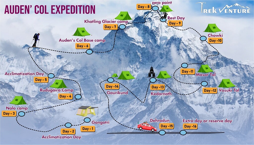
Day 1: Drive from Dehradun to Gangotri
The journey will begin at Gangotri, a mountain town located on the banks of the Bhagirathi River. Gangotri is widely recognised as the place where the holy River Ganga emerges from the earth. Located in the Greater Himalayan Range, it is said to be the place where Goddess Ganga crashed to the ground after Lord Shiva had released the river from the strands of hair that were entangled in the river. This holy city is situated at an elevation of 3,415 metres, and the nearest city that has an airport to it is Dehradun. The distance between the two is 245 km. If you have arranged to take a trip with Bikat from Dehradun to Gangotri, the day will get underway at an early hour. Everyone has arrived at the designated meeting spot by seven in the morning so that we may get started on the tough journey up to Gangotri, which is a holy mountain city located in the state of Uttarkashi.
Day 2- Acclimatization Day
Read MoreThe second day is reserved for rehabilitation as well as getting used to the higher altitude. It is very important that you do this in order to give your body time to acclimatise to its new environment and to reduce the likelihood that you may acquire adverse health concerns. You may take a walk around the marketplace, investigate the colours and culture of this mountain hamlet, and go to some of the attractions in the surrounding area. It’s possible that doing some sightseeing around the city can help you adjust more quickly. Take advantage of this opportunity to go over your packing list and make any last-minute purchases of supplies that you may need for the walk. We make advantage of this opportunity to get together with the group for a debriefing session while the body adapts to the new environment. Here is where we get to know one another better and discuss the events that will take place over the next few days, including the schedule, what to anticipate, general dos and don’ts while in the mountains, how to preserve the sanctity of the environment, and other important topics. In addition, in the evening we go on a short acclimatisation walk so that we may adjust our bodies and minds to the new surroundings more quickly.
Day 3- Trek from Gangotri to Nala camp
On the first day of our trip through this treacherous terrain, we make our way up to an altitude of around 350 metres. The bulk of the walk is spent winding through dense forest, with just sporadic access provided to teeny-tiny meadows and expansive vistas of the sky above. We leave Gangotri in a southwesterly direction and descend the main valley for almost two km before making a sharp left to the east and entering the Rudugaira valley. After this point, the trail continues to wind through dense oak and birch woodlands as it gradually climbs higher. As soon as you cross the nala, the tree line will begin to thin down, making way for greater tracts of countryside in the form of meadows and grazing areas. As we make our way to the campsite for the day, it is a great sight to witness Gangotri III and Jogin II, which resemble a shark’s fin when seen from a precise angle. After making it to the campground, we take a little respite from our tiredness, refuel with a hot dinner, and then go out for an acclimatisation stroll in the early evening.
Day 4: Trek from Nala Camp to Rudugaira Camp
The objective for the day requires going up 600 metres in elevation over a relatively small span of 4 km. It goes without saying that the ascent to Rudugaira Base Camp will be arduous and steep; in fact, it already is. As the trail continues past the Nala Camp, it begins its ascent to the upper grazing areas. If you’re lucky, you’ll get to see endless herds of Bharal, also known as Himalayan Mountain Goats, running around these high mountain meadows. We begin our journey by climbing a steep spur that, after crossing a few streams, will bring us straight to Rudugaira Base Camp. This will be our route. Our tents are set up in this breathtaking campsite that is blanketed in snow and is surrounded by well-known mountains such as Gangotri I, II, and III, as well as Jogin III.
Day 5- Acclimatization day
As we have travelled through very different terrain and reached a much higher elevation over the course of the last two days, we have decided to dedicate today to acclimating to the new altitude. After a later than usual breakfast, we get our bearings by going for a stroll. After climbing a few hundred metres above the campsite, we get our first glimpse of Auden’s Col, which is, to put it bluntly, an awe-inspiring sight. We call it a day early so that we may get the biggest amount of rest that we possibly can.
Day 6: Trek frim Rudugaira to Auden’s Col Base camp
Because the distance between our campground and the Gangotri base camp is approximately 4 kilometres, we get an early start today. After setting off on our trek, we almost immediately get our first look at Auden’s Col. The scenery is quite stunning to look at. Although it traverses a treacherous ridge that leads from the challenging Jogin I peak on the eastern side and an equally treacherous ridge that leads from the Gangotri III peak on the northwestern side, the col, which is covered in snow, gives the impression that it poses no threat. Now that we have left the slopes of the valley behind, we have reached the country of moraines, which makes the relatively short climb of four kilometres from Gangotri base camp to Auden’s Col base camp fairly difficult due to the height, terrain, and snow. After a long day of trekking through snow-covered moraines, our base camp at Auden’s Col is finally in sight. It is a desolate and uninhabited area. We are going to go right into the middle of Sukha Tal, a high-altitude lake that is known for its magnificent blue colour and its location hidden inside a moraine basin.
Day 7: Trek from Auden’s Col base camp to Khatling Glacier camp
THE time has finally arrived. The treacherous but spectacular Auden’s Col is where we will be trekking today. Gangotri III and Jogin I will be on each side of us, the Jogin glacier will be behind us, and Khatling will be in front of us. The day is going to drag on for a while. As we make our way closer to the glacier, we will continue to travel through the terrain that is dominated by moraines. After travelling for a short distance on the glacier, we will reach an area of elevation that must be navigated with extreme caution because to the steepness of its slope, which ranges from 30 to 50 degrees. We have to rope up in order to traverse this very steep portion that is around one and a half kilometres long. The ascent to the col ought to take something in the neighbourhood of three hours. However, the ascent is not the most difficult obstacle to overcome right now. When descending from the col, it can be difficult because you have to navigate a gully that has an angle of 70–75 degrees and is steep and narrow. However, once this gully is traversed, the glacier levels out, providing breathtaking panoramas of the enormous icefalls, glaciers, and intimidating peaks that can be found in the newly opened valley. After making a short descent of the glacier, we arrived at the campground where we would spend the night.
Day 8: Trek from Khatling glacier to zero point
Despite the fact that we have successfully traversed the pass and are now on the other side, the task has really just begun and will continue until it is completed. Today is going to be both one of the longest and one of the most difficult days of the adventure. The treacherous Khatling glacier, which is about ten km long and is littered with obstacles, is what we have to negotiate today. The Khatling glacier, which is located in one of India’s most heavily glaciated regions, is a moraine-rich terrain that has deep crevasses that are both exposed and hidden throughout each of its 10 km of length. This unmarked path through loose gravel and scree that includes stretches of steep ascents and descents requires you to proceed with the utmost caution at every step along the way.
Day 9: Rest Day
Because the previous two days were so challenging, today is a day of rest and recuperation at Zero Point for us.
Day 10: Trek from Zero point to Chowki
Today is the day that we will make our way out of the snowy region and make our way on our own to the warmer parts of the valley. After continuing our walk along the river for another three km, we finally make it to the meadows. After many days of hiking through the snow and boulders, our green campsite at Chowki was located four miles away, and we had to walk there.
Day 11: Trek from Chowki to Masar Tal
We are going to visit Masar Tal today, which is renowned as one of the most distant lakes in the Garhwal region. At an elevation of 4,135 metres, this picture-perfect lake may be found high up in the mountains, to the east of the beautiful Khatling glacier. The tour starts with a challenging ascent and a look of Thalay Sagar, which is a breathtaking peak that stands 6,904 metres tall and is situated 10 miles to the southwest of Gaumukh, which is a holy spot. After making the first ascent, we continue straight ahead over a ridge that runs parallel to the valley floor until we reach Masar Tal. We pitched our tent next to this beautiful lake.
Day 12: Trek from Masar Tal to Vasuki Tal
At a height of 4,135 metres, the glacial lake known as Vasuki Tal is our destination for today’s excursion. On the route we are taking today, getting to Masar Top begins with a challenging ascent over rocks along a ridge. The trail then descends for a short distance before beginning its ascent up the glacier to the top of Mayali Pass, which is yet another unexplored gem in Uttarakhand. When viewed from this vantage point, the descent is every bit as treacherous as the one we left behind when we descended from the Khatling glacier. In order to finish this part of the challenge, we will abseil down using fixed ropes. We will continue our descent all the way to Vasuki Tal, which is the lake where we will spend the night.
Day 13: Trek from Vasuki Tal to Kedarnath
After a very long trek, we will finally arrive at Kedarnath, which is considered to be one of the holiest shrines dedicated to Shiva. Kedarnath, one of the twelve Jyotirlings, is visited by a significant number of pilgrims during the times of the year when the surrounding area is free of snow cover. The journey from Vasuki Tal to Kedarnath is around 7 km long and takes approximately three to four hours to accomplish. After spent the previous days walking over chilly and bumpy terrain, we visit the temple in the evening before retiring for the night to a cosy bed at a nearby hotel.
Day 14: Trek from Kedarnath to Gaurikund
We do this by walking the 21 km over a straightforward and well designated trail. We have reservations at a hotel or a bed and breakfast for the night.
Day 15: Trek from Gaurikund to Dehradun
The fierce Ganga River may be observed when travelling back to Dehradun from this location. The trip should take anywhere between eight and nine hours to complete. If at all feasible, you should go to Dehradun by the evening.
Day 16: Extra day or reserve day
Day 16 has been set aside as a contingency day in case we are forced to detour from the route that has been planned for the whole of the journey due to poor weather or other unforeseen circumstances. We shall only resort to this option in the very unlikely event if unanticipated events occur at the very last minute and prevent us from reaching our destination as planned. If this day is used, there is an extra price of INR 4500 per person that must be paid. At the end of the walk, the person in charge of leading the walk will collect the same.
↬ Map of Auden’s Col Expedition

↬ Inclusion
- From Day 1 through Day 16 of your walk, you will be sleeping in various hotels and tents.
- All meals are provided, beginning with the first night’s dinner and ending with breakfast on day sixteenth. On all days of the walk, we provide simple, healthy vegetarian meals.
- We will provide for round-trip transportation from Dehradun to Dehradun
- Trekking permits and camping expenses in the woods are all accounted for.
- Tents and sleeping bags of the highest quality will be provided at each camp. Fortunately, we have high-altitude sleeping bags that are good down to ten degrees Celsius.
- Gaiters, microspikes, and ropes are available.
↬ Exclusion
- Costs associated with carrying personal items, such as luggage, on the hike.
- The term “emergency costs” refers to any and all costs that crop up as a direct consequence of a crisis.
- There will be no access to bottled water at any point throughout the walk


